Satellite Communication
GEO · DVB-S2 / DVB-RCS2 · TDMA / MF-TDMA · Bent pipe
NetSim's satellite library is an end-to-end, full-stack, packet-level simulator for communication between terrestrial nodes via a geostationary satellite, with advanced link models, antenna models, and frequency reuse. LEO and MEO orbits are supported via the NTN library.
What you can do with it
Standards-based simulation of satellite networks, from the radio link up to end-to-end application performance.
Full-stack satellite link
End-to-end, full-stack, packet-level simulation between terrestrial nodes via a geostationary satellite.
Forward & return links
TDMA on the forward link and MF-TDMA on the return link, with superframe, frame, and slot structure.
Bent-pipe relay
The transparent payload sends back to Earth what comes in, with amplification and an uplink-to-downlink frequency shift.
Link & antenna models
Free space path loss with Loo Markov and Rayleigh fading, antenna gain to noise temperature, and DVB-S2 MODCODs.
Standard and architecture
A single-satellite system following the DVB-S2 / DVB-RCS2 standards, with a transparent (bent-pipe) payload.
DVB-S2 / DVB-RCS2
- ETSI EN 302 307 V1.2.1 (August 2009) – DVB-S2
- ETSI EN 301 545-2 V1.2.1 (April 2014) – DVB-RCS2
- Modelled as a single-satellite system
Transparent payload
- Supports transparent payload (bent pipe)
- The satellite acts as a relay, amplifying and shifting from uplink to downlink frequency
- Interfaces with the Internetworks library for end-to-end connectivity
GEO, with LEO/MEO via NTN
- Geostationary satellite simulation in the satellite library
- LEO and MEO orbits supported through the NTN library
Specifications
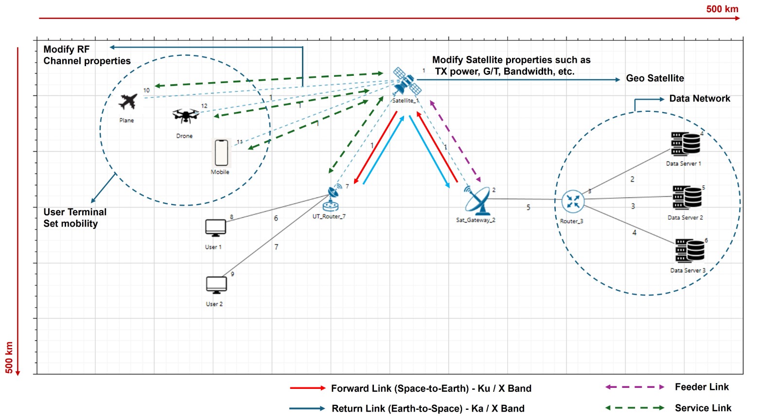
A single-satellite scenario with gateway, satellite, user terminals, and remote servers, configurable from the MAC frame down to the radio.
Network components
- UT node, UT Router
- Satellite, Satellite Gateway
- Remote server
Link specifications
- Feeder link: connects the gateway and satellite
- Service link: connects the satellite and UT
MAC layer models
- Superframe, frame, and slot structure
- Forward access protocol: TDMA
- Return access protocol: MF-TDMA
PHY layer models
- DVB-S2 / DVB-RCS2 per ETSI EN 302 307 and ETSI EN 301 545-2
- Channel model: free space path loss with Loo Markov and Rayleigh fading
- MODCODs per Table 12 of ETSI EN 302 307 DVB-S2
- Antenna gain to noise temperature (G/T)
Frequency bands
- Earth-to-space: Ku band (12–18 GHz) and X-band (7.9–8.4 GHz)
- Space-to-earth: Ka band (24–60 GHz) and X-band (7.25–7.75 GHz)
Propagation delay
NetSim computes the distance between the ground nodes and the satellite and divides it by the speed of light to obtain the propagation delay.
Protocols & applications
All transport protocols and all application types in unicast mode can run. The satellite library interfaces with the Internetworks library, so gateway and user terminals connect to remote servers.
Measurements & analytics
- Throughput, latency, error, and more
- Packet trace
- Radio measurements log: time, Tx power, Rx power, path loss, fading loss, noise, SNR
- Satellite log: forward/return superframe formation, frame and slot length, bandwidth, carrier details, and UT–gateway associations
Modulation & coding
Per Table 12 of ETSI EN 302 307 DVB-S2:
- QPSK — 1/4 · 1/3 · 2/5 · 1/2 · 3/5 · 2/3 · 3/4 · 4/5 · 5/6 · 8/9 · 9/10
- 8PSK — 3/5 · 2/3 · 3/4 · 5/6 · 8/9 · 9/10
- 16APSK — 2/3 · 3/4 · 4/5 · 5/6 · 8/9 · 9/10
- 16QAM — 3/4 · 5/6
- 32APSK — 3/4 · 4/5 · 5/6 · 8/9 · 9/10

The radio measurement log records Tx power, Rx power, path loss, fading loss, noise, and SNR per link.
Satellite communication protocol stack
From the forward and return links at the satellite, down through the MAC and PHY layers to the output logs.
- Access protocol: TDMA
- Band: Ku
- Range: 12-18 GHz
- Bent pipe
- GEO Stationary satellite
- Altitude (km): 35768
- Access Protocol: MF-TDMA
- Band: KA
- Range: 20-40 GHz
- Superframe, frame and slot structure
- Forward: TDMA and Return: MF-TDMA
- DVB-S2/DVB-RCS2 per ETSI EN 302 307 V1.2.1 (Aug. 2009) and ETSI EN 301 545-2 V1.2.1 (Apr. 2014)
- BER model: Model based, Fixed, File based
- MODCODs per table 12 from ETSI EN 302 307 DVB-S2
- Propagation models: Free space
- Fading models: Rayleigh, Markov loo
- Radio measurements
- Packet trace
- Buffer occupancy
- Satellite log
Related product
Satellite link budget & coverage planning
Where the satellite library simulates the network, NetSim Astra plans the constellation: satellite link budgets and RF coverage studies over real geography, with constellation visualization on a 3D globe. Use the two together to move from coverage design to end-to-end performance.
- Satellite link budget computation
- RF coverage and footprint studies
- Geographic constellation planning
Useful links
Documentation and support to take a satellite project further.